Buried Service Locating Done Easily With RIDGID
Nowadays utility engineers are facing ever-increasing difficulties in installing and maintaining buried assets, pipelines, cables, fibre optics and ducts. Partially, this is due to the increasingly overcrowded subsurface, not just in the major towns and cities where such congestion might be expected, but also in rural areas.
Today’s utility consumers are more likely to claim against loss from disruption of service and traffic authorities. At the same time, local councils are more open to charging for excessive damage to roads and pathways and the results of traffic diversions in a way that has rarely been seen in the past.
So, when it comes to knowing where it is safe to excavate to minimize the potential for loss of service or cost to the contractor for social and traffic interference, how does the modern engineer know that existing utility plans are accurate? In many parts of the world, existing plans are rarely up to date and often services have been moved to make way for other installations, building works or other diversionary reasons. It, therefore, becomes a pressure on the utility engineer to ensure that where it is necessary to dig, all possible checks have been made to avoid any potential hazards and delays. However, these checks in themselves have to be completed in the least disruptive way whilst offering complete, efficient and cost-effective mapping of the subsurface infrastructures.
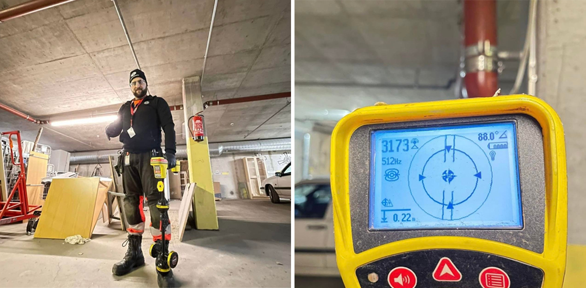
Aljbawi Abdullah and his RIDGID SR24 Line Locator getting ready for a locating job in Finland.
The RIDGID SR-24 And SR-20
As a provider of some of the world’s most cost-effective and efficient equipment to the utility industry, RIDGID offers buried service location equipment that does just this job.
The RIDGID SeekTech SR-24 and SeekTech SR-20, are the company’s primary instruments for the location of water, gas, telecommunications and electric utility services and have been specifically designed to enable field operatives, to locate and map underground pipelines, cables and ducts serving these utility providers.
Their design has been specifically engineered to make it an easy-to-use, simplified method for the site operator that also offers significant improvements in productivity and location confidence, without the need to have a highly qualified surveyor on site.
The SR-24 and SR-20 can operate in both Passive and Active Modes. Passive modes include 50-60Hz; low bandwidth (<4kHz), medium bandwidth (4-15kHz) and high bandwidth (>15kHz). Active modes include four line tracing frequencies (128Hz, 1kHz, 8kHz and 33kHz) and three radio sonde frequencies (16Hz, 512Hz, 16kHz) for use when a tracing sonde is passed through a pipeline being traced. In an active and passive power mode, the unit offers up to thirty (30) user-definable frequencies, which can be set from as low as 10 Hz to as high as 35,000 kHz. This is one of the broadest frequency ranges on the market today.
The innovative passive mode allows an operator to trace any type of passive signal that might be given off by a metallic line, without the line needing to have a specific generator attached to it. The wide range of passive bands on the SR-24 and SR-20 makes it useful for finding and avoiding powered lines or metallic services that the operator may not be aware of and which are not shown on any existing plans.
>
Simplicity In Location
The SR-24 and SR-20 stand out from the crowd on the locating market due to some ingenious operator assist functions that are believed to be unique in the sector. Whichever mode of operation is in use, the omnidirectional antenna design of the SR-24 and SR-20 has a total of eight (8) separate and differently aligned antennae. Six antennas are within the antenna balls on the main shank of the unit with two Guidance antennas set cross-wise close to the base of the shank.
The units' digital display also offers some unique capabilities, making the process of surveying easier for the operator. Starting with a set of cross-hairs, which is the locator position over the ground, the unit when tracing a powered cable displays a line in relation to the cross-hairs indicating the expected position of the cable in relation to the locator. If using a sonde for the trace inside a pipe, the display offers an outline of where the pipe is likely to be in relation to the locator. By moving the locator to bring the cross-hairs over the line or pipe outline the operator positions the unit precisely over the utility without having to search for it by constantly repositioning, rotating or tilting the locator.
Once over the line or pipe outline the operator simply keeps the cross-hairs on the display line to follow the route of the buried utility. Straying off the utility route is prevented by keeping the cross-hairs aligned with the predicted route which is modified by the unit as the survey progresses along the utility track.
The SR-24 which, in addition to the range of options offered by the SR-20, has the built-in capacity to utilize GPS and Bluetooth® technology to enable easy integration of survey results with external data capture devices. With the SR-24 you can stream captured data directly to smartphones, tablets, or high-precision GPS instruments. A specific and free mobile app, RIDGIDTrax has been developed for the SR-24, which enables basic underground utility mapping in real-time.
By connecting a device wirelessly with Bluetooth to a RIDGID SR-24 Utility Locator and RIDGID Trax will display GPS position and depth of the target utility. A user can identify the type of utility (water, gas, electric, etc.) and display multiple utilities on the same map. A finished map can be saved and viewed inside the app or can be exported as a *.KML file for use with popular GIS programs.
Accessories that can be used with the SR-24 and SR-20 for tracing buried utilities include (depending on the circumstance of each individual trace/locate):
· A Line Transmitter
· An Inductive Signal Clamp
· A Remote transmitter
· A Floatable sonde
· The SeeSnake Camera transmitter
These signal generation options and the signal response and flexibility of the SR-24 or SR-20 make these locators one of the most efficient, time-saving, economical and user-friendly utility tracing systems in the modern market.
Stay in touch with us, subscribe to our monthly newsletter and discover our social media channels HERE.